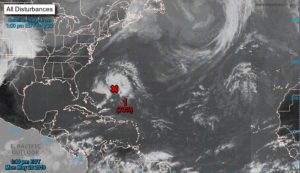
Andrea forms, the first probable Caribbean Tropical Storm


For the North Atlantic ... Caribbean Sea and Gulf of Mexico: 1.

Showers and thunderstorms associated with a wide area of ​​low. Pressure several hundred miles southwest of Bermuda is showing signs of organization. Although recent satellite wind data suggests that the system currently lacks a circulation center, the environmental conditions are expected to be conducive.

For the formation of a short-lived tropical or subtropical cyclone. Later today or tonight. Conditions are expected to become unfavorable for further development by the end of Tuesday, and the disturbance is expected to merge with a cold front on Wednesday. A reconnaissance aircraft from the Air Reserve is currently en route To investigate the riot. Interests in Bermuda must Monitor the progress of this system. The next Tropical Special Weather Outlook will be issued today at 8 PM EDT.

* Possibility of training through 48 hours ... high ... 70 percent.

* Possibility of training through 5 days ... high ... 70 percent.


Fuente: NOA

10 MOST COMMON ERRORS COMMITTED IN THE FACE OF A HURRICANE

  • Believe it won't happen . It is necessary to follow the instructions of those who are in control of the situation and periodically review the official communications issued by the relevant local authorities.
  • Put adhesive tape on sales. This will not prevent the glass from falling apart at all, the fragments represent a danger to the safety of people inside the property; It is recommended to cover the doors and windows with material resistant to sustained winds of 300 km / h or higher.
  • Place blocks or sandbags at the entrance of the door to prevent the entry of water. These only help divert the water.
  • Believing that those who live on the coast are the only ones who should evacuate. In the vast majority of times when it comes to hurricanes category 3 and up, you have to follow the instructions of the local authorities and not do Ignore their recommendations. IT'S FOR YOUR OWN SAFETY!
  • Open doors or windows a little bit. Hurricane winds are extremely turbulent and powerful so an open window or door (even if it's at the back of the house) can be a perfect space for the entry of the hot air that can incur this ( Video click ) as well as the entrance of debris transported by the wind.
  • Do the "Panic Shopping". For this it is important to be attentive to the media and to carry out our preparation. Normally we have up to more than 1 week to prepare and not leave everything At the last minute!
  • Placing wood (plywood) on doors and / or windows. As much as you believe that wood is the right thing to protect your home or business, you are in big error. Since hurricanes very easily tend to throw objects in the wind, such as trunks, metal sheets, spectacular, etc. Which become high speed projectiles that easily pierce the wood (plywood) or the wood (plywood) is pulled out. The key is anchoring and resistance to protect yourself properly.
  • Not having an Emergency Kit. It is essential to have the basic kit as well as having the protection of the documents that you consider important, it is recommended to have them in a bag and protect in an easily accessible waterproof backpack.
  • Do not cut off the electricity and butane gas supply. At the time that the local authorities give notice of Orange Alert (set when a tropical cyclone has approached such a distance that it predicts the imminent impact of the wind line). You must take the precaution of turning off the electrical box (it supplies electrical current to the home and / or business) as well as closing the stopcock from butane gas.
  • Get out of your shelter without prior notice from local authorities. You repeatedly make the mistake of leaving when you think the hurricane is over, and don't be careful! it is very likely that if you perceive a calm or “end” of the hurricane at that precise moment you will find yourself in the EYE OF THE HURRICANE . It is necessary to be attentive to the indications of the jurisdiction of your locality.