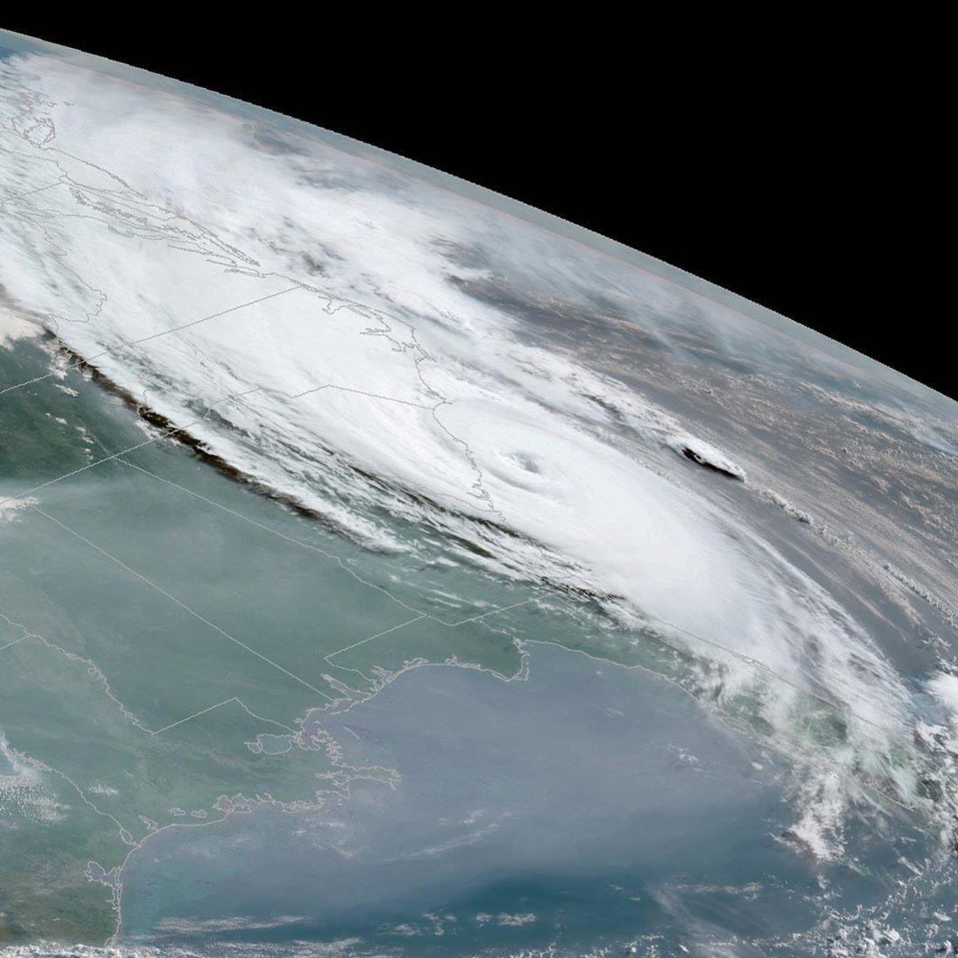
uncapped heroin from Hurricane Dorian.

Chella Phillips saved 97 dogs from dying.

As everyone knows The Bahamas has been viralized by that intense hurricane Dorian , a hurricane that will undoubtedly go down in history as one of the most devastating hurricanes so far in the Hurricane Season 2019 . You know now that the passage of the hurricane destroyed people's homes, flooded the streets and caused the death of at least five inhabitants.

Given the authorities' warning that the weather phenomenon would hit the Caribbean islands, residents prepared as best they could, bought groceries, and took refuge in shelters or their homes. But a woman named Chella Phillips worried not only about keeping her safe, but about street dogs that would have no place to shelter.

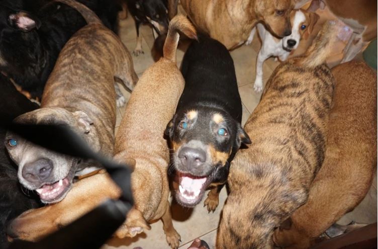
He opened the doors of his home to 97 ownerless canines so that they could be safe during hurricane storms.

CHELLA PHILLIPS.

Chella Phillips had to share her room with 79 dogs, but that was the easiest part of having rescued them. Keeping them and their brother who accompanied her in their shelter safe was difficult. The first night Dorian's eye fell on the Bahamas, rain began to flood his home. They used three pumps to drain the water but it was not enough and the liquid exceeded them . After an hour of relentless trying, all of the machinery had overheated and burned, so they had to try to scoop the water out, but they failed entirely.
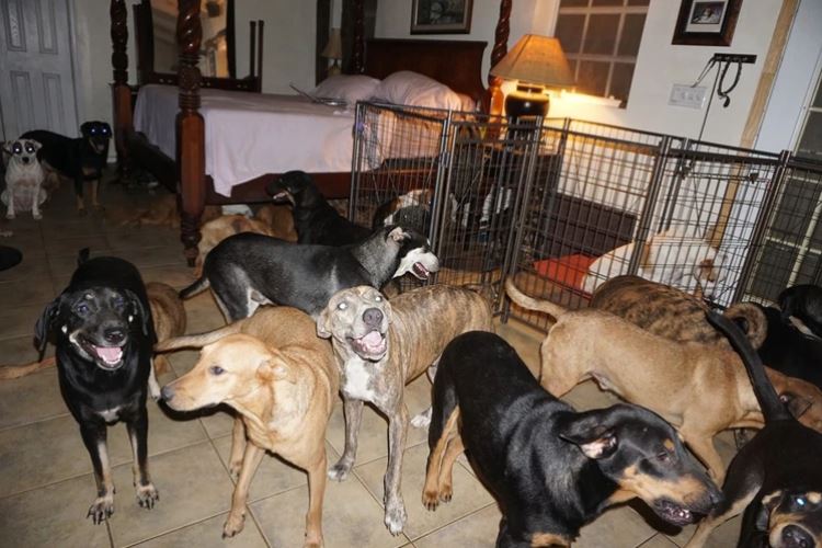
They ran out of services and their TV broke down from the lightning of the storms that hit the area, so she couldn't use the cartoons to entertain the dogs that were inside her house, and she won't be able to do until you get a new one.
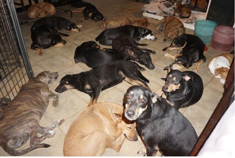
Despite the complications experienced, the Chella was able to keep the 97 dogs safe, with food and water.

Phillips is the director of The Voiceless Dogs of Nassau, a dog shelter in the Bahamas. "I am not affiliated with the Humane Society nor do I receive any kind of government aid. Only me and my love for these homeless dogs is what I do ", he says in the description on his Facebook page.

For eleven years, when she moved to the archipelago, she has been dedicated to helping street animals and four years ago she opened the refuge. During that time, with his own money and donations, he has managed to help 1,000 street dogs.
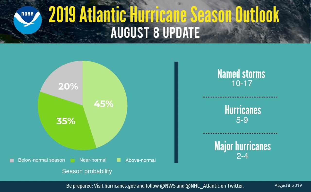
Increases the probability of having an Active Hurricane Season

10 to 17 named storms, 9 to 5 hurricanes, and 2 to 4 intense hurricanes are now expected.

Tormentas

10 a 17

Huracanes

9 a 5

Huracanes Cat. 4 o mayor

2 a 4

En National Hurricane Center (NOAA) informó la semana pasada que aumentó la posibilidad de tener una temporada de huracanes por encima de lo normal en lo que queda del año. El fenómeno de El Niño en el Océano Pacífico ha llegado a su fin, lo que propiciará que las condiciones   en el Océano Pacífico estén un poco más favorables para el desarrollo de sistemas tropicales. The probability that an above-normal Atlantic hurricane season is now 45% In May this year the NOAA said the probability of this was 30%
Fuente: NOAA

Disappearance of El Niño, with it will come strong cyclonic activity: specialist

The peak of the hurricane season begins in late August

The current season has behaved weakly, but it is not necessary to let your guard down , since the phenomenon of El Niño is close to disappearing and with this it will begin to take more forces cyclonic activity in the Atlantic Ocean.

The meteorologist of the Institutional Committee for the Attention of Extreme Meteorological Phenomena of the UADY, Juan Vázquez Montalvo, pointed out that, so far, the hurricane season has developed very weakly, presenting only one event in advance, in May, with the formation of the Hurricane Andrea and Barry, this month.

Danger

Vázquez Montalvo recalled that it is precisely in September when the Yucatan Peninsula has been vulnerable to major cyclones such as Gilberto and Isidoro, which hit the State in September.

“Since we no longer have the El Niño phenomenon, we will be in neutral conditions with tendencies for La Niña to form. During this period, the trend is to have explosive cyclone growth, which has not happened until now, "he insisted.

In this sense, he explained that El Niño with its cutting winds does not allow cyclones to form and there is an erratic behavior as it happened with Barry, which did not allow it to develop.

source: sipse.com

HURRICANE SEASON BEGINS 2019 How many hurricanes are expected?

The hurricane season began today in the Pacific and in the Atlantic it will begin in June, both will end in late November of this 2019. The names of the hurricanes are recycled every six years.

For this hurricane season in the Atlantic this is the forecast.

Asimismo, se pronosticó Centro Nacional de Huracanes (NHC, por sus siglas en inglés) que en el Océano Pacífico habrán 24 huracanes, mientras que para el Atlántico prevé 21.


source: Sipse.com

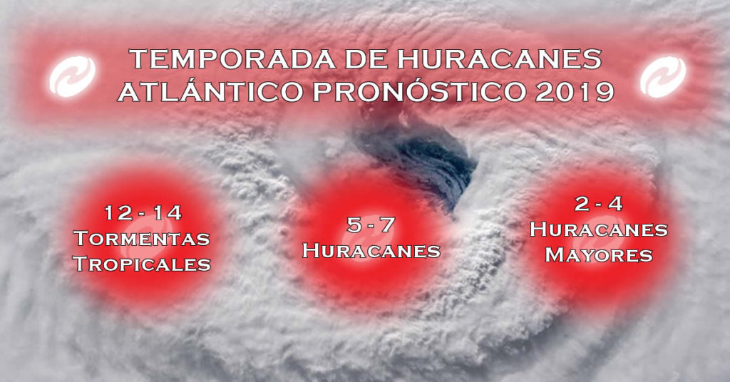
12-14 storms forecast for Hurricane Season 2019

The density map of the above tropical trajectory was created by analyzing analog years, which are past years that have weather patterns similar to current and projected weather patterns. Analogous years are often used to predict future trends and impacts during a hurricane season. They can be based solely on the El Niño phenomenon or on a combination of weather patterns and teleconnections, which are weather patterns that occur in another part of the world and that can significantly influence current or future weather in a particular area of ​​concern.

Luego de vivir una activa temporada de huracanes en el Atlántico el pasado año, el grupo de expertos de AccuWeather pronostica que el 2019 será una temporada ligeramente superior a la normal con un total de entre 12 a 14 tormentas. De esas tormentas, se pronostica que de cinco a siete se convertirán en huracanes, y de dos a cuatro en huracanes categoría tres o más. “Este año, creemos que habrá menos tormentas tropicales y menor número de huracanes, pero solo se necesita una para causar daño significativo”, dijo el experto en huracanes de AccuWeather, Dan Kottlowski. Después de que los huracanes Michael y Florence afectaran los EE. UU. el pasado año, el experto señala que pudiese repetirse la historia con el impacto de entre dos a cuatro fenómenos atmosféricos en la región. Para ayudar a predecir la próxima temporada, los pronosticadores han establecido comparaciones con años anteriores con condiciones climáticas comparables, también conocidos como años análogos. En este caso, por su similitud, el año análogo al patrón actual es el 1969. Durante esa temporada, el huracán Camille impactó la región de Mobile, Alabama, convirtiéndose en uno de los tres únicos huracanes categoría 5 que han impactado los Estados Unidos. Pero eso no significa que experimentemos algo similar este año, dijo Kottlowski. Al comienzo de la temporada, sin embargo, los meteorólogos de AccuWeather estarán monitoreando el potencial de desarrollo en la costa sureste, el Golfo de México y el Caribe. “Esas son las áreas que vigilaremos muy de cerca, no solo a partir de junio, sino desde abril y mayo, pues las temperaturas del Atlántico se encuentran elevadas”, dijo el experto.

THE HURRICANE SEASON IN THE ATLANTIC OFFICIALLY STARTS JUNE 1

If this [El Niño] pattern continues or strengthens, then the number of tropical storms and hurricanes will be near or below normal, "said Kottlowski. "If El Niño weakens and becomes neutral, the number of tropical storms and hurricanes could be higher than normal," he added. source: AccuWeather

2019, A YEAR WITH A LARGE NUMBER OF EXTREME METEOROLOGICAL PHENOMENA

The rainy season and tropical cyclones will begin on May 15, according to experts.


Mexico.- This year in the Pacific seas a weak El Niño phenomenon will be registered, which will generate a large number of extreme weather events and we must be ready to face them, warned Blanca Jiménez, director of the National Water Commission (Conagua).

During her participation in the inter-institutional meeting held at the National Center for Disaster Prevention (Cenapred), the environmental engineer stressed that we must be prepared for the imminent rainy season and tropical cyclones, which will begin on May 15 and end on November 30.

In order to establish the most appropriate lines of action to be applied before, during and after of a possible emergency, the proposal is to work, in a coordinated manner and putting aside any partisan affiliation, between the three levels of government , as well as establishing closer and closer communication with the population, added David León Romero, national coordinator of Civil Protection.

According to UNAM Global, to consolidate this strategy, the so-called Inter-institutional Analysis and Coordination Group for Tropical Cyclones was established, consisting of:

  • Ministry of Public Security (SSP)
  • Ministry of Communications and Transportation (SCT)
  • Ministry of the Environment and Natural Resources (SEMARNAT)
  • Ministry of National Defense (SEDENA)
  • Secretary of the Navy (SEMAR)
  • Federal Electricity Commission (CFE)

“We are working together and in a preventive way before the next season of tropical cyclones and rains. Therefore, in addition to operating as a team, we are reviewing the coordination, information and communication mechanisms between institutions in order to respond to any emergency before, during and after, ”they reported.

On May 15 the number of hurricanes that are calculated in the country will be announced in a meeting in Zihuatanejo, Guerrero.

The coordinator explained that in order to face these contingencies and lessen their impacts, a plan articulated in three axes is contemplated: prevention, preparation and communication.


source: SIPSE.COM

WARNING RISK OF IMPACT OF A HURRICANE IN YUCATÁN

Specialists affirm that the risk increases since a system has not reached Yucatan for a long time; will be two Atlantic cyclones that are category three or greater

According to specialists on the subject, the hurricane season in the Atlantic would be within normal standards for this year, although it was specified that several forecasts are still missing to be presented in the coming months, so that Yucatan must be aware of the reports.

According to specialists on the subject, the hurricane season in the Atlantic would be within normal standards for this year, although it was specified that several forecasts are still missing to be presented in the coming months, so that Yucatan must be aware of the reports.

  • 13 Cyclones
  • 8 Tropical Storms
  • 3 Moderate hurricanes between categories 1 and 2
  • 2 intense hurricanes categories 3 or greater

Although it is unknown when and where they would form.

Likewise, it was reported that there will be more forecasts in the months of June and July and one more at the end of August, although everything indicates that when El Niño ends, this could give way to cyclonic systems at sea Atlantic, so Yucatan must be pending.

Last year, 15 tropical systems were formed in the Atlantic, of which at least two, "Flourish" and "Michael", caused severe damage in the United States, resulting in the season was cataloged as catastrophic, according to specialists.

Likewise, it was mentioned that in the case of Yucatan, THE RISK OF AN IMPACT OF A HURRICANE IS GREATER BECAUSE FOR SEVERAL YEARS AGO, A SYSTEM DID NOT REACH THE ENTITY; THE LAST ONE WAS “Isidoro” IN 2002, WHILE “Dean” DID HIS OWN IN 2007 AT THE PENINSULAR LEVEL.

Fuente: la verdadnoticias.com