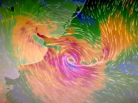
HOW CAN HUMANS INFLUENCE THE INTENSITY OF HURRICANES?

In the las decades, numerous studies have suggested that global warming could increase the number and intensity of tropical cyclones. However, recent research has shown that human emissions of greenhouse gases should already have caused a small increase on the intensity of tropical cyclones worldwide. But while there has been an increase in greenhouse gases in the atmosphere and the oceans have clearly warmed in recent decades, the global trend in the strength of tropical cyclones, does not coincide with the increase in these factors.

SCENARIO

In the view of this large puzzle of factors with big uncertainties that influence the potential intensity of tropical cyclones, NOAA produced simulations considering four different scenarios:

  • What happens if we had never started burning fossil fuels (without greenhouse gases, without aerosols?
  • What happens if we emit greenhouse gases, but not aerosols?
  • What happens if we emit aerosols, but not greenhouse gases? and
  • What is the scenario considering greenhouse gases and aerosols?

Beginning with the simplest scenario: if we hadn´t experimented with burning fossil fuels, the sea surface temperature and the potential intensity of the cyclones would have remained approximately the same approximate since 1850 until now. But if we look at what happens with the greenhouse gases and aerosols, so, the reality scenario 4) the surface sea temperature has clearly increased, but the potential intensity of the tropical cyclones has not. It has fluctuated slightly but we have not seem the same clear upward trend in the sea surface temperature until the past 2 decades. When we look at scenarios 2 and 3 things get very interesting. The computer model shows that the warming the warming provided by the greenhouse gases at the sea surface temperature is 2 to 3 times greater than the cooling effect of aerosols.

However, the increase in the potential intensity caused by the greenhouse gases is almost the equal to the decrease caused be aerosols.

In spite of the aerosols action, acting against greenhouse gases effects, the published study in the magazine “Natural Hazards” showed that, in the absence of a strong decrease of these gases emissions, the potential futures strength of greenhouse gases will dominate each time more the impact of aerosols, which will lead to substantially major increase in the intensity of tropical cyclones.

When we look at scenarios 2) and 3) things get very interesting. The computational model shows that the warming provided by greenhouse gases at sea surface temperature is two to three times greater than the cooling effect.

Creditos: Meteored.com.ar

What is an Extratropical Cyclone?

Es un sistema atmosférico cuya fuente primaria de energía es el gradiente horizontal de la temperatura. Los ciclones extratropicales son sistemas de baja presión asociados a frentes fríos, cálidos o ocluídos. Los ciclones tropicales, a diferencia de los extratropicales, no manifiestan un gradiente horizontal de temperaturas tan sustancial en todo el diámetro de la tormenta, a nivel de la superficie, y sus vientos son generados por la liberación de energía durante la formación de las nubes y la lluvia; estos se componen por dos o más masas de aire (cálido o frío), por lo tanto se asocia a uno o más frentes.

The upper diagrams show horizontal maps of surface temperature, pressure, and wind fields associated with a tropical cyclone (left) and an extratropical cyclone (right) . Colors indicate temperature (blue 15 ° C = 59 ° F, green blue 20 ° C = 68 ° F, green 25 ° C = 77 ° F). Dashed lines indicate surface wind speeds: 34 kt = 39 mph = 63 kph, 64 kt = 74 mph = 117 kph, and 96 kt = 110 mph = 174 kph. Continuous lines are the isobars.
The diagrams below show maps of vertical pressure surfaces, temperature anomalies, and surface circulation and tropopause.

The strongest winds in a tropical cyclone occur near the earth's surface, while in an extratropical cyclone the strongest winds occur near the tropopause (at a height of 12 km (8 miles). These differences arise as a consequence of that the tropical cyclone has a "warm core" in the troposphere (below the tropopause), while the extratropical cyclone has a cold core in the troposphere and warm in the stratosphere (above the tropopause). The expression "warm core" it means that the center of the cyclone is warmer than the environment at the periphery of the storm, on the same isobaric surface (speaking of isobaric surfaces is like speaking of heights from the ground). Contribution Stan Goldenberg source: NOA

2019, A YEAR WITH A LARGE NUMBER OF EXTREME METEOROLOGICAL PHENOMENA

The rainy season and tropical cyclones will begin on May 15, according to experts.


Mexico.- This year in the Pacific seas a weak El Niño phenomenon will be registered, which will generate a large number of extreme weather events and we must be ready to face them, warned Blanca Jiménez, director of the National Water Commission (Conagua).

During her participation in the inter-institutional meeting held at the National Center for Disaster Prevention (Cenapred), the environmental engineer stressed that we must be prepared for the imminent rainy season and tropical cyclones, which will begin on May 15 and end on November 30.

In order to establish the most appropriate lines of action to be applied before, during and after of a possible emergency, the proposal is to work, in a coordinated manner and putting aside any partisan affiliation, between the three levels of government , as well as establishing closer and closer communication with the population, added David León Romero, national coordinator of Civil Protection.

According to UNAM Global, to consolidate this strategy, the so-called Inter-institutional Analysis and Coordination Group for Tropical Cyclones was established, consisting of:

  • Ministry of Public Security (SSP)
  • Ministry of Communications and Transportation (SCT)
  • Ministry of the Environment and Natural Resources (SEMARNAT)
  • Ministry of National Defense (SEDENA)
  • Secretary of the Navy (SEMAR)
  • Federal Electricity Commission (CFE)

“We are working together and in a preventive way before the next season of tropical cyclones and rains. Therefore, in addition to operating as a team, we are reviewing the coordination, information and communication mechanisms between institutions in order to respond to any emergency before, during and after, ”they reported.

On May 15 the number of hurricanes that are calculated in the country will be announced in a meeting in Zihuatanejo, Guerrero.

The coordinator explained that in order to face these contingencies and lessen their impacts, a plan articulated in three axes is contemplated: prevention, preparation and communication.


source: SIPSE.COM