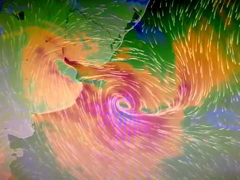
Hurricane Gilberto 1988

Gilberto the terrible hurricane of the 20th century

It is considered to be one of the most devastating cyclones on record in the Atlantic Ocean.

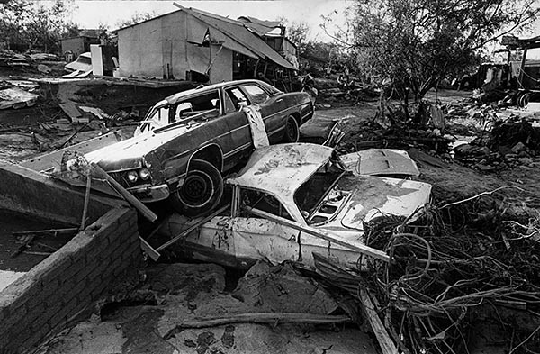
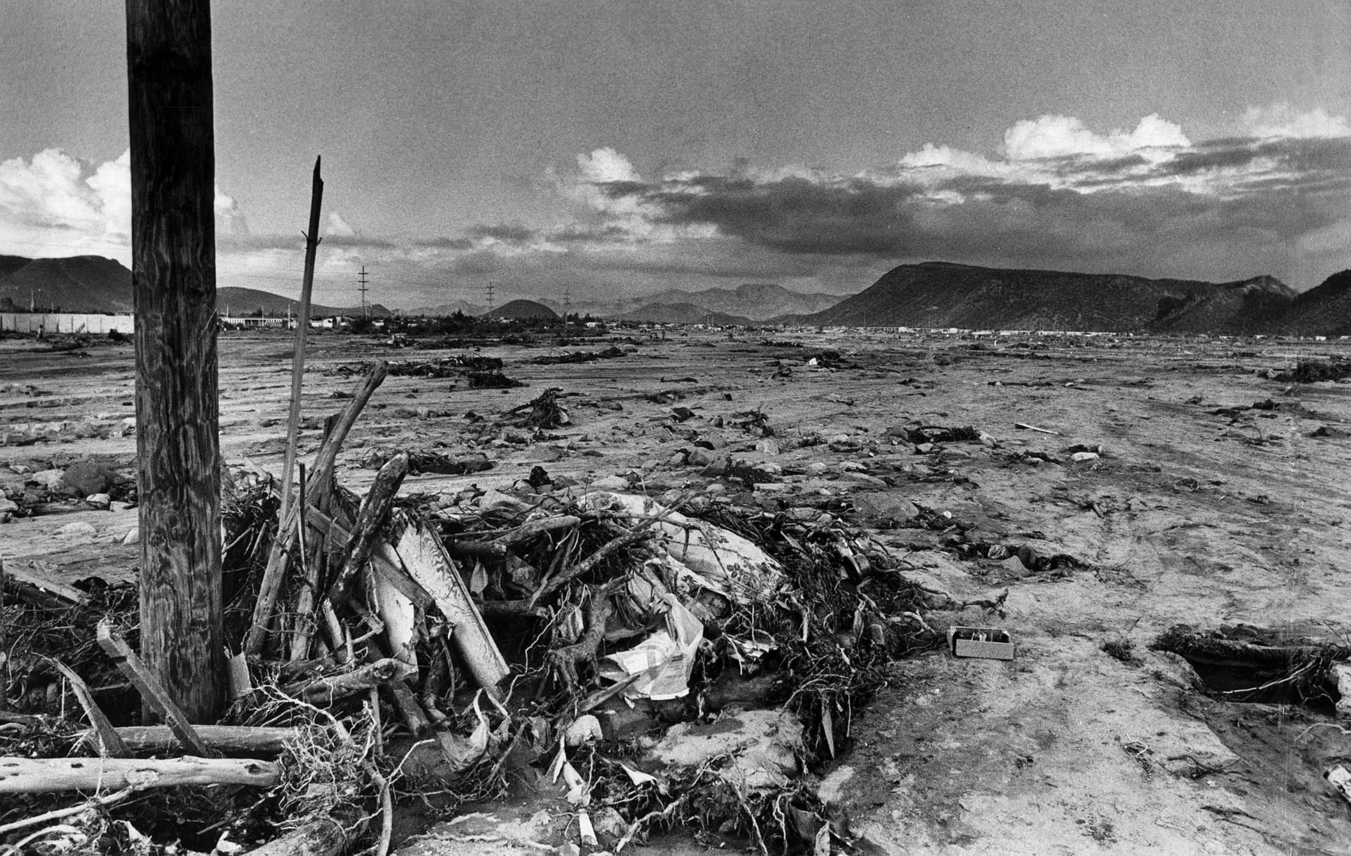
In Mexico, Gilberto lashed the states of Quintana Roo, Yucatán, Campeche, Nuevo León, Coahuila and Tamaulipas , causing the death of at least 250 people , and close to 150 thousand victims , as well as losses of 750 million dollars .

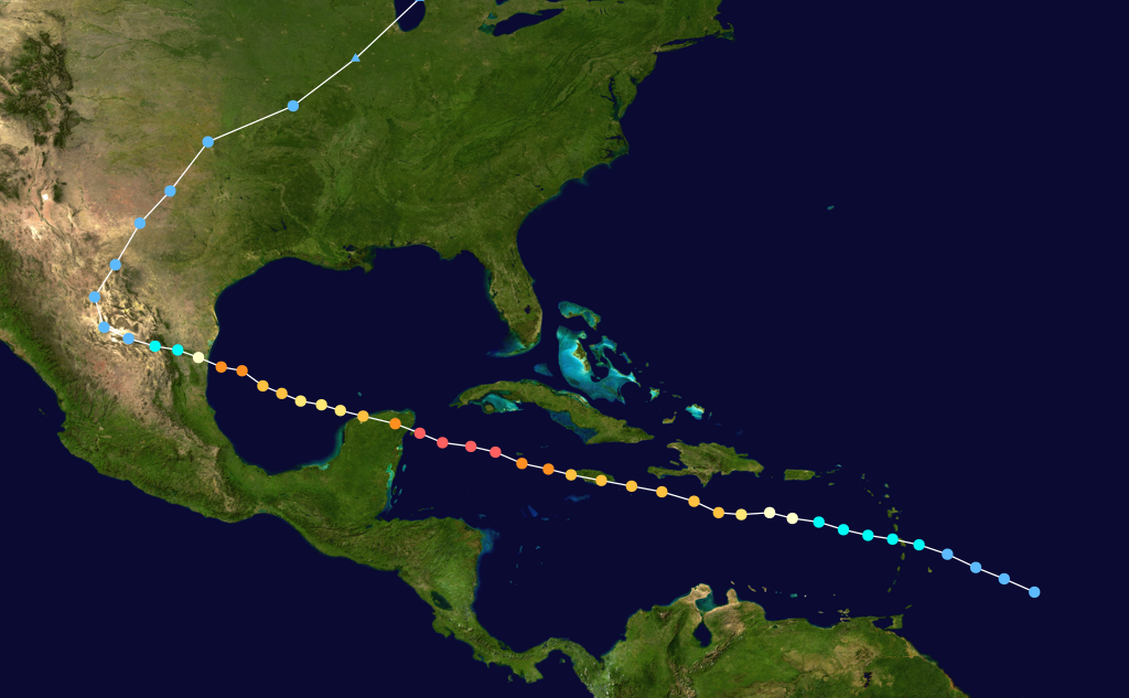
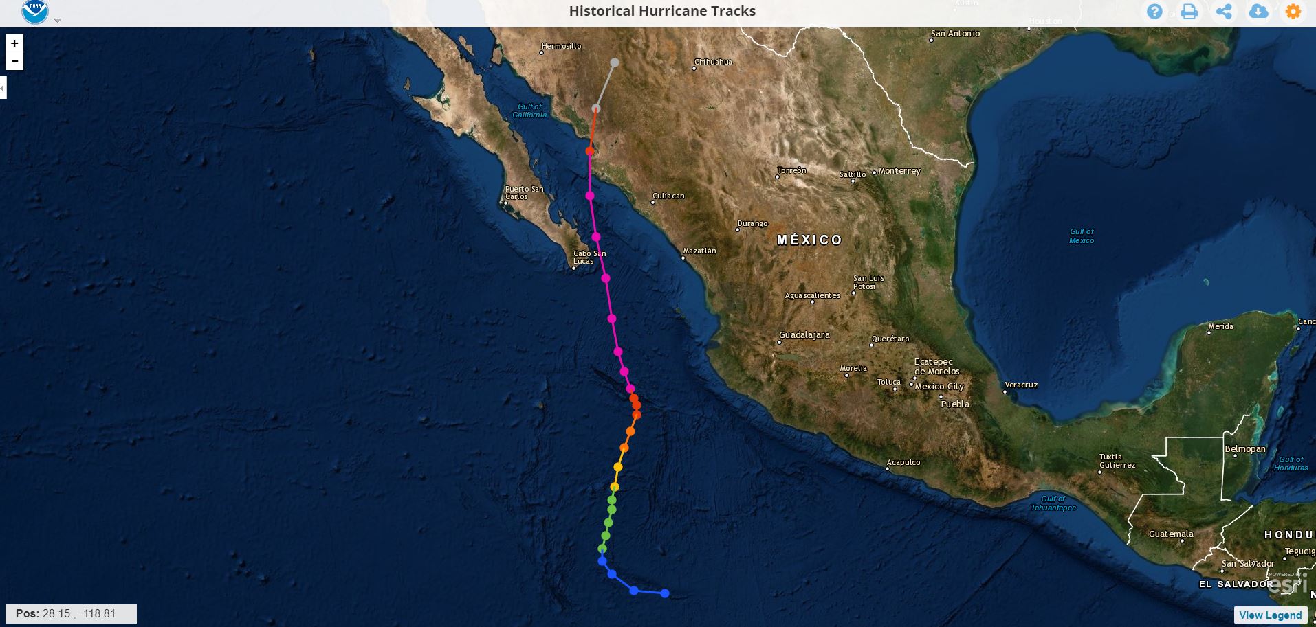
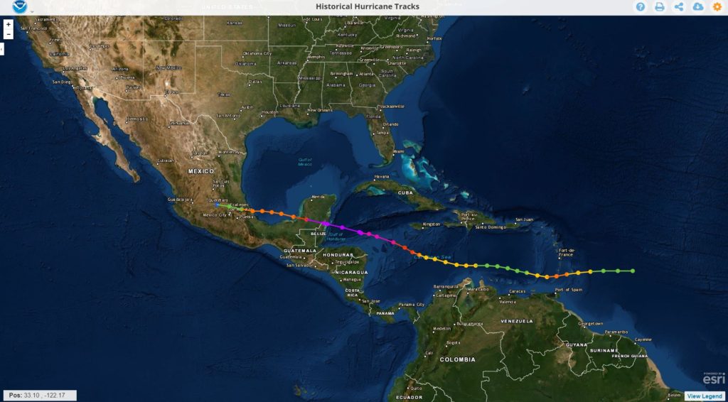
The hurricane known as the 20th century , was formed on September 8, 1988 as a tropical depression, during its movement through the Caribbean water It intensified into a Category 3 hurricane .

Foto: Unión Cancún

It struck the Island of Jamaica causing the death of 49 people , in addition to millionaire losses in infrastructure, as well as serious damage to crops

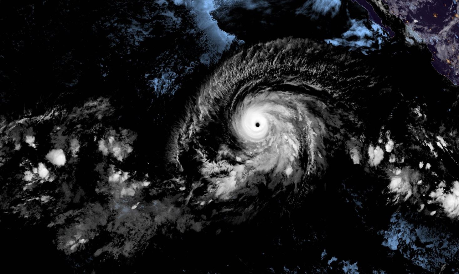
After leaving Jamaica, Gilberto quickly intensified again, reaching sustained winds of 296 km / h and made landfall again on September 14 in the Peninsula of Yucatan, being already a powerful Category 5 hurricane , being Cozumel the first affected, continuing its journey on land by Playa del Carmen, X-can, and Chemax , maintaining its same category 5 up to 85 kilometers inland .

Foto: Grupo SIPSE

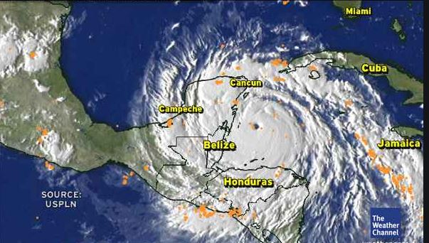
It was until 3:30 p.m. that his intensity decreased to category 4 during his time at Tizimín . He left Yucatan at around 19:00 hours , leaving in his wake close to 35,000 victims , 60,000 homes destroyed and damages for more than $ 1 million .

Hurricane Liza 1976

This hurricane reached category 4 on September 30, 1976 before hitting the southern peninsula of Baja California and Sonora with force, it hit the bay of La Paz leaving in its wake a great devastation, and -to date more than 43 years after the event- there is no official death toll; The virtual sources that recall the cyclone indicate that the Ángel César Alvarado government initially spoke of 600 people being killed, however, since then it has been speculated that the victims could be between 2,000 and up to 5,000 . The natural phenomenon left 10,000 victims, with total damages of 3 million pesos .

Of course: all the sources consulted coincide in pointing to this cyclone as " The worst disaster in the history of Baja California Su r"

Oct. 2, 1976: Car rests on top of second in aftermath of Hurrican Liza that lashed La Paz, Mexico. Over 400 people were died in La Paz. This photo was published in the Oct. 3, 1976 Los Angeles Times.

Real evidence of Mrs. Irma

What Doña Irma remembers the most is the next day: October 1, when with her husband and son they went home to the Infonavit neighborhood .

"It looked like La Paz had been bombed," he said. In the course of his parents' house to his home, crossing as best they could by the Forjadores, he assures that from Morelos High School to Colima he saw approximately 30 or more citizens dead, semi-buried and full of mud , who had literally been thrown onto the streets by the streams. Many more did not have the same "luck", as the current took them directly to the sea, without their whereabouts ever being known.

Hurricane Janet 1955

Renaissance Monument after Hurricane Janet (1955)

It is the first of which there is a record. The Hurricane Janet cataloged as category 5 on the Saffir-Simpson scale, made landfall on September 27, 1955, in Quintana Roo. According to the press of the time, the most affected city was precisely its capital, Chetumal, leaving 712 dead in its wake (data from Cenapred ) and devastated practically all the houses that were found since most of them were made in such a way.

Unusual cases:
Each hurricane has its own way of leaving its mark and leaving something in particular that the population does not forget, in the case of Hurricane Janet, how to forget the flag that crossed a tree, from which there is a replica on the esplanade of the flag (main park of Chetumal). Another unusual case is that of the “flying house” and the concrete pond that was wound on a palm tree. The "flying house" exists is made of wood and zinc sheet, it is on the Veracruz road with 22 de Enero corner in the center of the city. The anecdote, " was dragged more than 500 meters from its initial location, with about 25 people inside, during the impact of Janet" .

This was the path Janet took

As it happens in our days, many people left the protection of their family and their homes until the end . Expensive they would pay big mistake. In addition, just a few days earlier, on September 19, another hurricane had visited south of Quintana Roo "Hilda" that had basically passed through the area of ​​Felipe Carrillo Puerto, causing very slight damage in Chetumal. Then it was naively thought that this had already covered the "annual quota" of hurricanes, today we know that this does not work that way, even the worst was lacking ...

Increases the probability of having an Active Hurricane Season

10 to 17 named storms, 9 to 5 hurricanes, and 2 to 4 intense hurricanes are now expected.

Tormentas

10 a 17

Huracanes

9 a 5

Huracanes Cat. 4 o mayor

2 a 4

En National Hurricane Center (NOAA) informó la semana pasada que aumentó la posibilidad de tener una temporada de huracanes por encima de lo normal en lo que queda del año. El fenómeno de El Niño en el Océano Pacífico ha llegado a su fin, lo que propiciará que las condiciones   en el Océano Pacífico estén un poco más favorables para el desarrollo de sistemas tropicales. The probability that an above-normal Atlantic hurricane season is now 45% In May this year the NOAA said the probability of this was 30%
Fuente: NOAA

Hurricanes, earthquakes, and other natural disasters

Hurricanes, earthquakes, and other natural disasters obey the same mathematical patterns.

Taking note of the magnitude of various catastrophic natural phenomena and plotting on a graph how many episodes of each of them have occurred throughout history, the result is not unpredictable. Quite the contrary, it follows a very well-defined curve in which, luckily, the greater their devastating capacity, the less frequently they convert.

For example, very few earthquakes become catastrophic, while numerous small earthquakes or earthquakes continually occur that most of them are so weak that they go unnoticed by people and can only be detected by very sensitive instruments. But this information is essential to calculate the associated risks.

However, this dependency is not always the same or conforms to the same mathematical function, particularly with respect to larger events. Álvaro Corral and Álvaro González, researchers from the Center for Mathematical Research (CRM) and the Department of Mathematics of the UAB, have carried out an accurate statistical analysis of a whole set of natural phenomena that can cause disasters: Earthquakes, Hurricanes, Forest fires, Meteorite impacts in the atmosphere, torrential rains and subsidence of the ground.

After analyzing the data of thousands of episodes of different intensity of each one of these phenomena, these researchers have managed to describe with the same mathematical technique the functions that relate the frequency of these phenomena to the value of their magnitude or size. Most of them follow the so-called power law , according to which the events are more and more abundant the smaller they are, without having a “normal” or typical size

Hurricane Hazards

While hurricanes pose the greatest threat to life and prosperity, tropical storms and depression can also be devastating. The main hazards from cyclones (including tropical depressions, tropical storms, and hurricanes) are storm floods, inland flooding from heavy rains, destructive winds, tornadoes, and high rip currents.

  • The storm surge .- It is the abnormal increase in water generated by the winds of a storm. This hazard is historically the leading cause of hurricane related deaths in the United States. The storm surge and huge waves can cause great loss of life and cause massive destruction along the coast.
  • Floods .- Due to heavy rains, they are the second leading cause of death from tropical cyclones. Widespread torrential rains associated with these storms often cause flooding hundreds of miles inland. This flood can persist for several days after a storm has dissipated.
  • Los vientos.- Cuando son de un huracán pueden destruir edificios y casas prefabricadas. Las señales, el material del techo y otros elementos que se dejan afuera pueden convertirse en misiles voladores durante los huracanes.
  • Tornadoes .- They can accompany tropical cyclones that make landfall. These tornadoes generally occur in rain bands far away from the center of the storm.
  • Waves .- They are produced by strong winds and very dangerous due to a tropical cyclone and can represent a significant danger for coastal residents and sailors. These waves can cause deadly rip currents, significant beach erosion, and damage to structures along the shoreline, even when the storm is more than 1,600 kilometers from shore.

Disappearance of El Niño, with it will come strong cyclonic activity: specialist

The peak of the hurricane season begins in late August

The current season has behaved weakly, but it is not necessary to let your guard down , since the phenomenon of El Niño is close to disappearing and with this it will begin to take more forces cyclonic activity in the Atlantic Ocean.

The meteorologist of the Institutional Committee for the Attention of Extreme Meteorological Phenomena of the UADY, Juan Vázquez Montalvo, pointed out that, so far, the hurricane season has developed very weakly, presenting only one event in advance, in May, with the formation of the Hurricane Andrea and Barry, this month.

Danger

Vázquez Montalvo recalled that it is precisely in September when the Yucatan Peninsula has been vulnerable to major cyclones such as Gilberto and Isidoro, which hit the State in September.

“Since we no longer have the El Niño phenomenon, we will be in neutral conditions with tendencies for La Niña to form. During this period, the trend is to have explosive cyclone growth, which has not happened until now, "he insisted.

In this sense, he explained that El Niño with its cutting winds does not allow cyclones to form and there is an erratic behavior as it happened with Barry, which did not allow it to develop.

source: sipse.com

What is an Extratropical Cyclone?

Es un sistema atmosférico cuya fuente primaria de energía es el gradiente horizontal de la temperatura. Los ciclones extratropicales son sistemas de baja presión asociados a frentes fríos, cálidos o ocluídos. Los ciclones tropicales, a diferencia de los extratropicales, no manifiestan un gradiente horizontal de temperaturas tan sustancial en todo el diámetro de la tormenta, a nivel de la superficie, y sus vientos son generados por la liberación de energía durante la formación de las nubes y la lluvia; estos se componen por dos o más masas de aire (cálido o frío), por lo tanto se asocia a uno o más frentes.

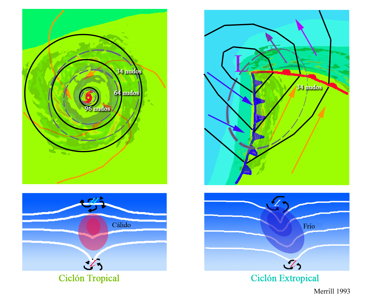
The upper diagrams show horizontal maps of surface temperature, pressure, and wind fields associated with a tropical cyclone (left) and an extratropical cyclone (right) . Colors indicate temperature (blue 15 ° C = 59 ° F, green blue 20 ° C = 68 ° F, green 25 ° C = 77 ° F). Dashed lines indicate surface wind speeds: 34 kt = 39 mph = 63 kph, 64 kt = 74 mph = 117 kph, and 96 kt = 110 mph = 174 kph. Continuous lines are the isobars.
The diagrams below show maps of vertical pressure surfaces, temperature anomalies, and surface circulation and tropopause.

The strongest winds in a tropical cyclone occur near the earth's surface, while in an extratropical cyclone the strongest winds occur near the tropopause (at a height of 12 km (8 miles). These differences arise as a consequence of that the tropical cyclone has a "warm core" in the troposphere (below the tropopause), while the extratropical cyclone has a cold core in the troposphere and warm in the stratosphere (above the tropopause). The expression "warm core" it means that the center of the cyclone is warmer than the environment at the periphery of the storm, on the same isobaric surface (speaking of isobaric surfaces is like speaking of heights from the ground). Contribution Stan Goldenberg source: NOA

Barbara escalates to powerful Category 4 hurricane

Climate change in action?


Tropical Storm Barbara in the Pacific Ocean quickly became a Category 4 hurricane and developed, achieving a record time of less than 24 hours. This fact leaves a strong message that the rapid development of these systems must be monitored even more today as there is increasing speed and intensity.

It is a great hurricane , fortunately it will not impact national terrain, however, there is vigilance for Hawaii .

source: catastrofesmundiales.com

Reefs and QRoo Beach have hurricane insurance

La Conanp detalló que el seguro, ofrecido por Afirme Seguros, permitirá tener fondos para reparar los daños al arrecife.

The National Commission for Protected Natural Areas ( Conanp ) reported that the reefs and beaches of Quintana Roo already have a hurricane insurance policy and detailed that this policy is the first of its kind.

He added that this action is a strategic and innovative step as it recognizes the importance of the benefits that nature provides to people and the economy, the risk to which they are exposed and the need to conserve them.

The reefs maintain the tourism industry in Quintana Roo, providing valuable coastal protection against storms, reducing erosion of beaches , producing white sand and attracting more than one million divers a year.

While reefs are exposed to various threats, hurricanes are an extreme risk, as category 5 storms, for example, can wipe out 60 percent of live coral cover and cause serious structural damage in just a few hours.

Conanp explained that the insurance, offered by Affirm Insurance, will allow funds to repair damage to the reef after a hurricane, which will reduce losses to the economy and its ability to protect the coastal zone.

As part of this project, the The Nature Conservancy, the Conanp and the Regional Center for Aquaculture and Fisheries Research (CRIAP) will provide training to the so-called Reef Guardians, who they have the ability to rehabilitate reefs in Isla Mujeres, bringing the total number of Reef Guardians to 60 in this region.

source: MVSNoticias