Hurricane Manuel 2013

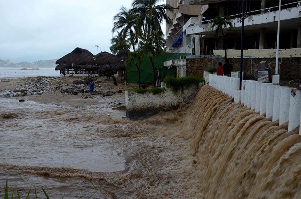
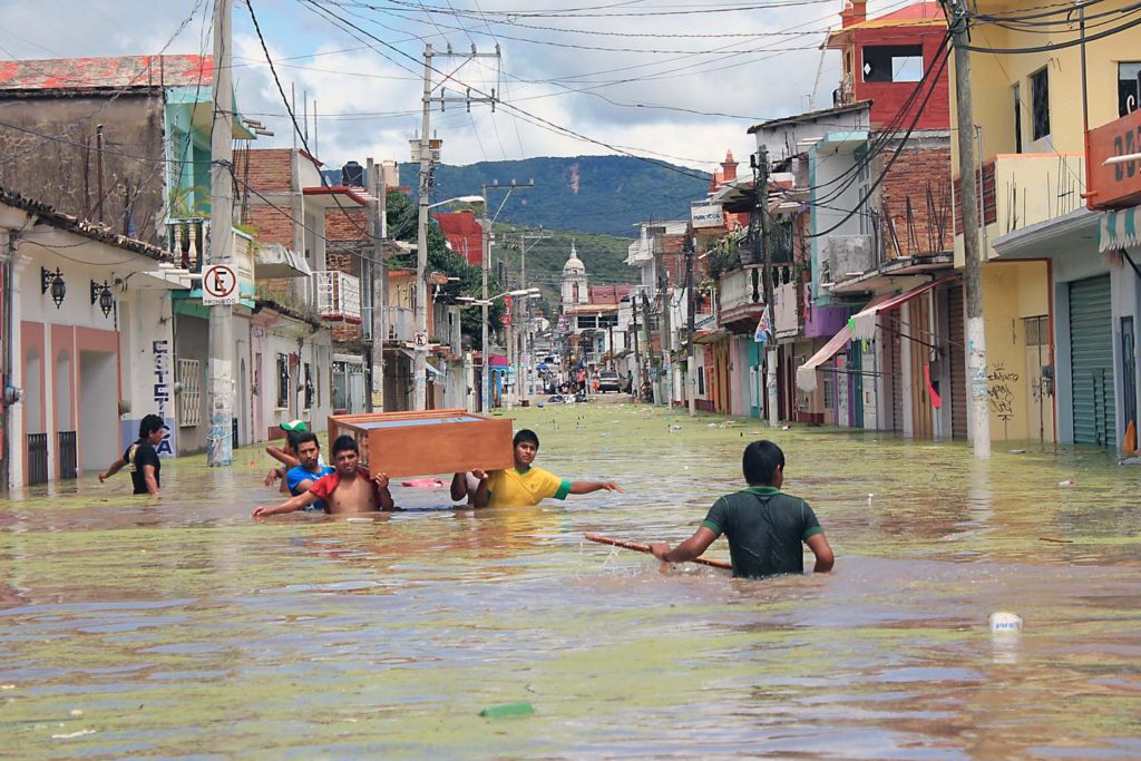
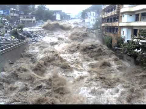
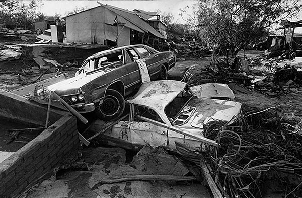
Although it was only category 1 , Manuel left 123 dead , 97 of them occurred in an avalanche in the community of La Pintada, Guerrero . It was also brutalized with Coahuila , Chihuahua and Durango . In addition, there were more than 59 thousand evacuees and at least 218 thousand 594 people affected . Economic losses were estimated at $ 242 million .

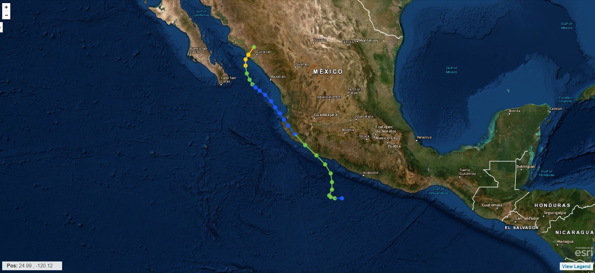
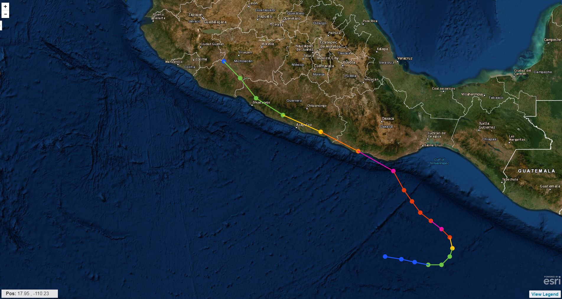
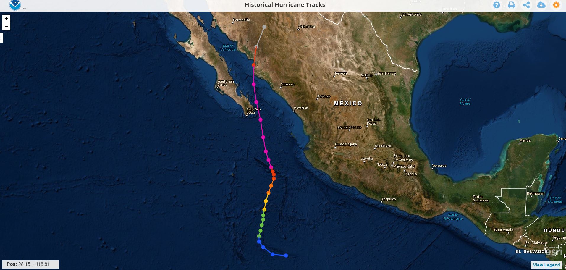
On September 13 in the morning the tropical depression No. 13 of the Pacific Ocean was generated, which was formed from a low pressure off the coast of Guerrero that finding favorable conditions led to a tropical depression Thirteen , which started with sustained winds of 55 km / h , gusts of 75 km / h and moving northwest at 6 km / h .

During the day 14 , the tropical storm " Manuel " began with a stationary period and then began its course heading north, moving smoothly erratic while increasing its strength off the coast of Guerrero and Michoacán , causing a wide area of ​​dense cloudiness, whose rotation favors the significant entry of moisture into the southern and western states of the country.

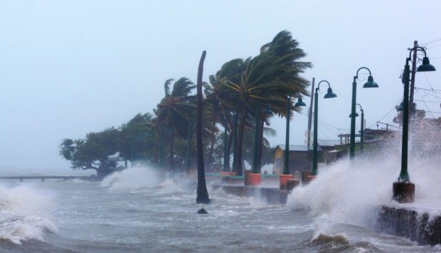
On September 15 , around 2:00 pm, the tropical storm " Manuel " made landfall over the City of Manzanillo, Colima with maximum sustained winds of 100 km / h and gusts of 130 km / h , when advancing on land, the system began to lose strength due to which at 22:00, was already in the vicinity of the population of El Limón, Jalisco, as a tropical depression with maximum sustained winds of 55 km / h , gusts of 75 km / h and moving northwest at 13 km / h

At 01:00 a.m. September 16 , the tropical depression " Manuel " was located 25 km northeast of Tomatlán, Jal ., moving northwest at 13 km / h, very close to weakening at low pressure. At 4:00 on the same day, DT “ Manuel ” was already at sea again as a low pressure remaining with maximum sustained winds of 45 km / h and gusts of 65 km / h.

The low pressure, remaining from " Manuel " continued its journey to the northwest and on September 17 in the afternoon, when it was 120 km west-southwest of Mazatlán, Sin., Regenerated to a tropical depression with maximum sustained winds of 55 km / h and gusts of 75 km / h , the same force with which it was maintained until morning of day 18 , when it developed for the second time in its path to a tropical storm, being 160 km south-southwest of Culiacán, Sin., with maximum sustained winds of 65 km / h and gusts of 85 km / h.

While gaining strength, the tropical storm “Manuel” began to enter the southern part of the Gulf of California and at 7:00 p.m. on the 18th, when it was 180 km south-southeast of Topolobampo, Sin., It intensified to hurricane acquiring maximum sustained winds of 120 km / h with gusts of 150 km / h , strength with which it was maintained until 19 September at noon, when it touched the Sinaloa coast; upon touching land, “Manuel” began to lose strength, so at 13:00 it was located 65 km north-northeast of Altata, Sin., as a tropical storm, with maximum sustained winds of 100 km / h and gusts of 120 km / h.

"It was very maddening because we didn't know what was happening, but when the energy came back it was worse because we knew that everything was closed and we couldn't leave Acapulco."

Esther Jiménez.

Hurricane Wilma 2005

The fierce hurricane made landfall in Mexico and tests the comprehensive prevention plan.

On October 21, 2005 Hurricane Wilma made landfall off the coast of Quintana Roo. With sustained winds that reached 280 km / h , it left one million victims in the country and economic losses of 30 million pesos , according to official figures.

The threat of the hurricane that gained brutal force in just 24 hours, going from category 2 to category 5 , with maximum sustained winds of 280 km / h this was something that really impacted everyone.

The phenomenon affected our country, where it claimed 4 victims, as well as Haiti, leaving 12 dead ; Cuba likewise 4 dead ; the Bahamas one person died from his attack ; and the United States left a balance of 3 1 dead.

A residence in the Hotel Zone, Cancun, Q. Roo.

"There is a terrible wind, the few trees that were already fell, blown away by the wind, only one radio is transmitting information, that of the City Council, but the antenna is getting worse and worse and it can fall at any time"

Edna del Valle, living in the Miramar Poniente neighborhood for MORE THAN 10 YEARS.

Hurricane Paulina 1997

One of the deadly, destructive and expensive cyclones during the second half of the 20th century.

Paulina originated from a tropical wave on October 5, 1997 410 km south-southwest of Huatulco, Oaxaca. Initially it had an eastward shift, but then turned north-northwest. During the day October 7 , Paulina registered its maximum intensity reaching the category 4 on the scale of Saffir-Simpson with sustained winds of 215 km / h and gusts of up to 240 km / h . On the afternoon of October 8 , it made landfall near Puerto Escondido, Oaxaca, causing serious damage to the coast of that state. At dawn on October 9 , he parked in the state of Guerrero, leaving the port of Acapulco practically destroyed, Paulina would dissipate in the early hours of the day October 10 in the state of Jalisco.

Hard to believe but this image was taken in Acapulco, Guerrero.

Unusual

Entire families were engulfed by the flows that devastated the hills, whose slopes were covered with irregular settlements. The cardboard, wood and palm districts, many of them built on the banks of rivers and streams, disappeared entirely from the map.

No doubt he spent a full week in the midst of terror with the sense of survival triggered to protect yours and your own life.

Testimony

Paulina produced a torrential record rainfall in Acapulco of 411.2 mm accumulated in less than 24 hours. The floods severely affected leaving 230 to 400 people dead . Nearly 300,000 people were left homeless and damages of 80 billion pesos were recorded.

Hurricane Liza 1976

This hurricane reached category 4 on September 30, 1976 before hitting the southern peninsula of Baja California and Sonora with force, it hit the bay of La Paz leaving in its wake a great devastation, and -to date more than 43 years after the event- there is no official death toll; The virtual sources that recall the cyclone indicate that the Ángel César Alvarado government initially spoke of 600 people being killed, however, since then it has been speculated that the victims could be between 2,000 and up to 5,000 . The natural phenomenon left 10,000 victims, with total damages of 3 million pesos .

Of course: all the sources consulted coincide in pointing to this cyclone as " The worst disaster in the history of Baja California Su r"

Oct. 2, 1976: Car rests on top of second in aftermath of Hurrican Liza that lashed La Paz, Mexico. Over 400 people were died in La Paz. This photo was published in the Oct. 3, 1976 Los Angeles Times.

Real evidence of Mrs. Irma

What Doña Irma remembers the most is the next day: October 1, when with her husband and son they went home to the Infonavit neighborhood .

"It looked like La Paz had been bombed," he said. In the course of his parents' house to his home, crossing as best they could by the Forjadores, he assures that from Morelos High School to Colima he saw approximately 30 or more citizens dead, semi-buried and full of mud , who had literally been thrown onto the streets by the streams. Many more did not have the same "luck", as the current took them directly to the sea, without their whereabouts ever being known.

Increases the probability of having an Active Hurricane Season

10 to 17 named storms, 9 to 5 hurricanes, and 2 to 4 intense hurricanes are now expected.

Tormentas

10 a 17

Huracanes

9 a 5

Huracanes Cat. 4 o mayor

2 a 4

En National Hurricane Center (NOAA) informó la semana pasada que aumentó la posibilidad de tener una temporada de huracanes por encima de lo normal en lo que queda del año. El fenómeno de El Niño en el Océano Pacífico ha llegado a su fin, lo que propiciará que las condiciones   en el Océano Pacífico estén un poco más favorables para el desarrollo de sistemas tropicales. The probability that an above-normal Atlantic hurricane season is now 45% In May this year the NOAA said the probability of this was 30%
Fuente: NOAA

Hurricanes, earthquakes, and other natural disasters

Hurricanes, earthquakes, and other natural disasters obey the same mathematical patterns.

Taking note of the magnitude of various catastrophic natural phenomena and plotting on a graph how many episodes of each of them have occurred throughout history, the result is not unpredictable. Quite the contrary, it follows a very well-defined curve in which, luckily, the greater their devastating capacity, the less frequently they convert.

For example, very few earthquakes become catastrophic, while numerous small earthquakes or earthquakes continually occur that most of them are so weak that they go unnoticed by people and can only be detected by very sensitive instruments. But this information is essential to calculate the associated risks.

However, this dependency is not always the same or conforms to the same mathematical function, particularly with respect to larger events. Álvaro Corral and Álvaro González, researchers from the Center for Mathematical Research (CRM) and the Department of Mathematics of the UAB, have carried out an accurate statistical analysis of a whole set of natural phenomena that can cause disasters: Earthquakes, Hurricanes, Forest fires, Meteorite impacts in the atmosphere, torrential rains and subsidence of the ground.

After analyzing the data of thousands of episodes of different intensity of each one of these phenomena, these researchers have managed to describe with the same mathematical technique the functions that relate the frequency of these phenomena to the value of their magnitude or size. Most of them follow the so-called power law , according to which the events are more and more abundant the smaller they are, without having a “normal” or typical size

Hurricane Hazards

While hurricanes pose the greatest threat to life and prosperity, tropical storms and depression can also be devastating. The main hazards from cyclones (including tropical depressions, tropical storms, and hurricanes) are storm floods, inland flooding from heavy rains, destructive winds, tornadoes, and high rip currents.

  • The storm surge .- It is the abnormal increase in water generated by the winds of a storm. This hazard is historically the leading cause of hurricane related deaths in the United States. The storm surge and huge waves can cause great loss of life and cause massive destruction along the coast.
  • Floods .- Due to heavy rains, they are the second leading cause of death from tropical cyclones. Widespread torrential rains associated with these storms often cause flooding hundreds of miles inland. This flood can persist for several days after a storm has dissipated.
  • Los vientos.- Cuando son de un huracán pueden destruir edificios y casas prefabricadas. Las señales, el material del techo y otros elementos que se dejan afuera pueden convertirse en misiles voladores durante los huracanes.
  • Tornadoes .- They can accompany tropical cyclones that make landfall. These tornadoes generally occur in rain bands far away from the center of the storm.
  • Waves .- They are produced by strong winds and very dangerous due to a tropical cyclone and can represent a significant danger for coastal residents and sailors. These waves can cause deadly rip currents, significant beach erosion, and damage to structures along the shoreline, even when the storm is more than 1,600 kilometers from shore.

Reefs and QRoo Beach have hurricane insurance

La Conanp detalló que el seguro, ofrecido por Afirme Seguros, permitirá tener fondos para reparar los daños al arrecife.

The National Commission for Protected Natural Areas ( Conanp ) reported that the reefs and beaches of Quintana Roo already have a hurricane insurance policy and detailed that this policy is the first of its kind.

He added that this action is a strategic and innovative step as it recognizes the importance of the benefits that nature provides to people and the economy, the risk to which they are exposed and the need to conserve them.

The reefs maintain the tourism industry in Quintana Roo, providing valuable coastal protection against storms, reducing erosion of beaches , producing white sand and attracting more than one million divers a year.

While reefs are exposed to various threats, hurricanes are an extreme risk, as category 5 storms, for example, can wipe out 60 percent of live coral cover and cause serious structural damage in just a few hours.

Conanp explained that the insurance, offered by Affirm Insurance, will allow funds to repair damage to the reef after a hurricane, which will reduce losses to the economy and its ability to protect the coastal zone.

As part of this project, the The Nature Conservancy, the Conanp and the Regional Center for Aquaculture and Fisheries Research (CRIAP) will provide training to the so-called Reef Guardians, who they have the ability to rehabilitate reefs in Isla Mujeres, bringing the total number of Reef Guardians to 60 in this region.

source: MVSNoticias

IS YOUR HOME OR BUSINESS REALLY PROTECTED AGAINST THE FULMINATING FORCE OF A HURRICANE?

Is your home or business really protected from the sudden force of a hurricane?


Many people when asking this really believe that if they are protected and ready to react to the withering force of a hurricane, which we leave you…

Reasons why obtaining cyclonic protection is convenient for you and your family.

Living in a coastal region, it is important not to go unnoticed and to consider how dangerous the impact of a cyclone could be. When taking safety precautions it is easy to underestimate the amount of damage a hurricane can cause, however it is substantial that you take the time to prepare your family and property in the event of a storm.

The safety of yours is paramount, for this reason, we give you some reasons and / or recommendations why becoming a creditor of anticyclonic protection is a smart decision.


1.- PROTECT YOUR HOME DURING THE PASSAGE OF A HURRICANE

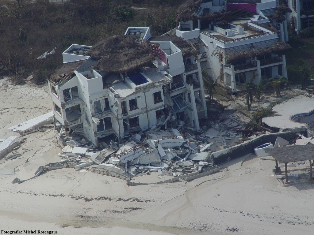
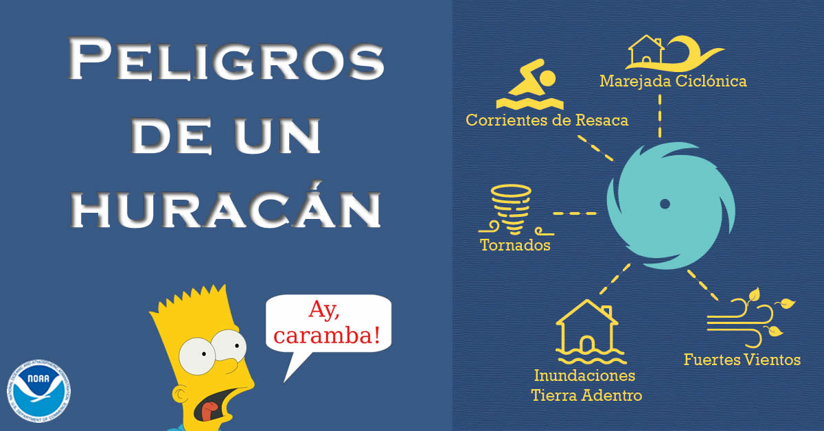
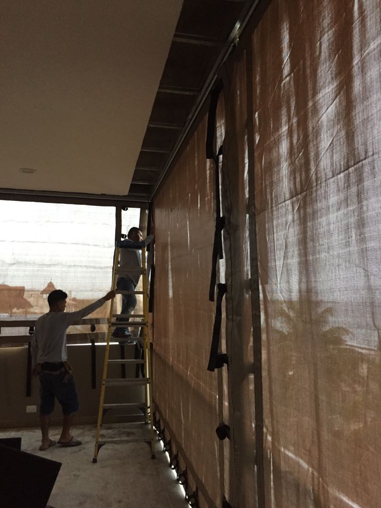
Hurricanes have been increasing in strength over the years due to global warming, which puts very great pressure on the windows that are exposed to it, and breaks them easily, leaving your property vulnerable to rains and debris that can cause significant damage to your home.

An anti-hurricane security system, keeps any possible threat off your property, keeping you and your family totally healthy and safe.


2.- EASY TO INSTALL

Stormcatcher en acción

There are two types of anticyclonic systems ( temporary and permanent ) which are chosen depending on the preference of the client. Many times to take care of your facade or visually it looks great, since any modality protects.

In the case of temporary (polypropylene anticyclonic mesh, panels) they can be mounted and dismounted when the client needs it; On the other hand, the permanent such as aluminum blinds, folding aluminum, will be fixed to your window giving security whenever you require it.

3.- LONG-TERM BENEFITS

Compared to other forms of protection against hurricanes, such as impact windows or reinforced doors, the security benefit is acquired in the long term, since taking into account the low cost it has, it also resists much longer than other types of solutions .

The range of protections is very varied, as well as there are different factors which can make one type of protection more optimal than others, such as window measurements, location or community regulations.

Investing in a cyclone protection system is a decision that can provide future benefits, in short it is a smart decision.

HURRICANE SEASON BEGINS 2019 How many hurricanes are expected?

The hurricane season began today in the Pacific and in the Atlantic it will begin in June, both will end in late November of this 2019. The names of the hurricanes are recycled every six years.

For this hurricane season in the Atlantic this is the forecast.

Asimismo, se pronosticó Centro Nacional de Huracanes (NHC, por sus siglas en inglés) que en el Océano Pacífico habrán 24 huracanes, mientras que para el Atlántico prevé 21.


source: Sipse.com